

A 481-Meter Tsunami Struck Alaska, And It Was a Terrifying Near Miss
As Earth’s climate warms, glaciers are retreating. This is evident all around the world.
Glacial retreat isn’t always a peaceful process and can significantly affect the landscape. Our fleet of Earth-observing satellites bears witness to these changes.
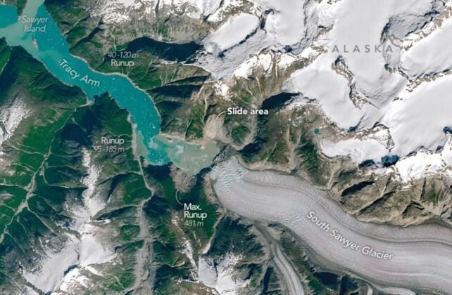
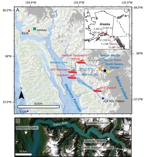
In 2025, the retreating South Sawyer Glacier in Alaska’s Tracy Arm, a fjord near Juneau, triggered a large landslide.
As debris from the landslide smashed into the water, it triggered a megatsunami that swept down the fjord into the ocean.
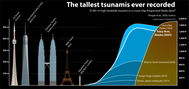
On its way down, it reached a maximum height of 481 m (1,578 ft) – the second-highest tsunami known to humans.
A team of scientists led by Dan Shugar, a geomorphologist at the University of Calgary in Canada, reconstructed the tsunami and published their results in Science.
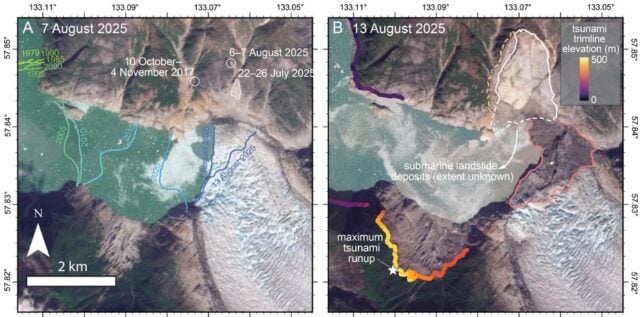
The researchers used satellite images, aerial images, and ground-based data to understand how the event unfolded.
“The bright landslide scar on the north side of the fjord is striking, as is the ‘bathtub’ ring around the fjord showing the areas where the forest was leveled by the tsunami,” Shugar said in a press release.
The glaciers themselves have shaped the fjords. Glaciers are like massive, slow-moving rivers of ice, and just as rivers have carved out vast features like the Grand Canyon, glaciers have carved out the Alaskan fjords.
Fjords like Tracy Arm prevent tsunamis from spreading out and dissipating their energy. Instead, the water barrels down the fjord, running up the sides in some places and stripping away trees and vegetation.
Sawyer Island, about 9 km down the fjord, was almost stripped clean, with only a few trees left standing.
As the researchers explain in their paper, landslide-generated tsunamis can reach higher heights than earthquake tsunamis, “owing to larger, localized variations in water depth and direct water-column displacement by slope failure – most pronounced in confined water bodies like fjords.”
In their paper, the authors also stressed the growing risk from tsunamis like this one.
“With fjord regions increasingly visited by cruise ships, and climate change making similar events more likely, this unanticipated, near-miss event highlights the growing risk from landslides and tsunamis in coastal environments,” the authors write.

The tsunami’s effect on the fjord wasn’t confined to the day it occurred. For more than 24 hours after the initial event, water continued to “slosh” around in the fjord in what’s called a seiche.
Together with the landslide, the seiche produced seismic signals that were equivalent to an earthquake at 5.4 on the Richter scale.
There were no injuries from this tsunami, but there nearly were. Some kayakers camping on an island at the fjord’s mouth had their kayaks and their gear swept away. A small vessel in Endicott Arm, a neighbor to Tracy Arm, saw strong currents and changes in the water level.
As Alaskan cruises grow in popularity, the risk from landslide tsunamis will only increase. Ironically, it’s the retreating glaciers themselves that attract more traffic.
“Fjords with retreating tidewater glaciers are increasingly popular destinations for cruise ships and smaller vessels throughout the Arctic and Subarctic, particularly in southeast Alaska,” the researchers write.
“In the past few years, cruise ship passenger numbers in Alaska have increased from an annual average of ~1,000,000 in 2016 to ~1,600,000 in 2025.”
In their conclusion, the authors point out that “warming climates increase the frequency of large landslides in glaciated fjords…”

They also say that seismic waves from the landslide-induced seiches from these events could shed some light on how to acquire early warnings of them in the future.
Related: First Detailed Look at a Tsunami From Space Reveals Unexpected Feature
“This offers a new pathway for near-real-time detection of hazardous fjord processes in regions with sparse tide-gage data or satellite coverage, motivating automated seismic searches for narrowband signals as part of early-warning frameworks,” they write.
This article was originally published by Universe Today. Read the original article.
What did you think of this news? Leave a comment below and/or share it on your social media. This way, we can inform more people about the hottest things in technology, science, innovation, and gaming!
This news was originally published in:
Original source